Instrumentation

Devices for sensing and recording

Emlid Reach RS2/2+/3 GNSS/GPS receivers

 Emlid Reach RS2/2+/3 receivers enable georeferencing for a wide range of geoscience and geophysics applications. Survey points can be used to generate topographic data sets, to determine the position of other surveys (e.g., seismic nodal arrays, seismic refraction profiles, ground penetrating radar, electrical resistivity), or to record data collection points (e.g., sample locations).

Related categories:

GNSS/GPS Receivers

Global Navigation Satellite System (GNSS) receivers sense incoming signals from the USA’s Global Positioning System (GPS) satellites and other constellations (GLONASS, Galileo, BeiDou, etc.). With signals from four or more satellites, the receivers use trilateration to determine a position.

Related categories:

Pegasus Datalogger

The Pegasus is a 3 channel high-resolution data logger. It is very low power and easily configurable via a handheld device. The Pegasus is lightweight and small in form factor. The Pegasus has 32 gigabytes of internal recording space, and is downloaded via free software through USB. It supplies MiniSEED data along with StationXML to smoothly allow data archival. It also has built-in sensor controls, automatic mass re-centering, and calibration functions. The Pegasus is currently supplied as a set with a Trillium Compact sensor for a small station footprint and ease of installation.

Features:

Related categories:

Magnetotelluric Systems at EPIC

Magnetotelluric (MT) methods are used to produce conductivity models of the crust and upper mantle through the recording of geoelectric and geomagnetic field variations at the Earth's surface. Depending on the period of the recordings, these methods can provide results from a few hundred meters depth (short period) to 30 km or deeper (long period). Conductivity is a physical property, which is complementary to seismic velocity, and which is very sensitive to the presence of fluids. When seismic and MT data sets are measured together, the additional data can dramatically improve determinations of the structure of the crust and mantle.
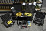
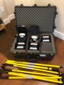
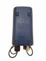


Since 2019, the EPIC (formerly known as EPIC) has been developing MT resources to meet PIs needs. We currently have a wide pool of MT equipment including both long-period (LEMI) and wideband (Phoenix) systems.


Syndicate content