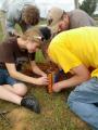
Here are some of the articles that have been recently posted to the PASSCAL website:

Education and Public Outreach at EPIC - French School Visit

On Friday, November 1st 2013, a group of students and teachers from Bethesda, Maryland's Lycée Rochambeau/ French International School visited the EarthScope/EPIC facility on Socorro NM for some hands-on demonstrations of how seismic measurements are used to "see" geological strata underground.  The class, led by instructor Marc Roux, head of the Biology and Geology Department, were assisted by EPIC scientists Greg Chavez and Michael Johnson during the deployment of a long string of geophones and a multi-channel data acquisition system.  The students then used heavy hammers to produce active source tremors, and then were able to see the seismic responses in real time.  The class assembled in the EPIC conference room to hear EPIC scientists/data specialists Dr. Wallis Hutton and KatyLiz Anderson discuss how such measurements can be used to find the depth of subsurface structures like the Moho.  The visit was capped with a tour of the EPIC facility, led by scientist/software engineer Dave Thomas. (Photo: student Salomé Carcy; credit: Dr. Wallis Hutton)

Related categories:

Poles and Zeroes

All poles and zeroes in radians/sec

Flexible Array

Overview

The USArray Flexible Array is a pool of instruments that is available for PI-driven research projects associated with the goals of EarthScope.  This pool of instruments is housed at the EarthScope EPIC located at New Mexico Tech in Socorro, NM. The pool consists of broadband (325), short-period (100), accelerometer (20), and controlled source (1700) stations. Using both natural and controlled sources, these portable instruments permit high-density, short-term observations of key targets within the footprint of the larger Transportable Array. USArray's flexible component offers exciting opportunities for a variety of focused investigations requiring higher-resolution images embedded within the context of the Transportable Array.

Related categories:

Batholiths Onland 2009 Photo Recap

In July 2009, several EarthScope/EPIC scientists assisted with the Batholiths Onland project. This large group effort involved over 50 scientists and grad students, for the purpose of making "a seismic refraction and wide-angle reflection survey across the Coast Mountains batholith of British Columbia, Canada."

Related categories:

EPIC's Polar Group Revs Up for Antarctic Summer

This is the time of year when the Polar group at EPIC is busy deploying teams to the Antarctic. Since polar conditions make for difficult site installations, EPIC is pleased to present the following instructive videos of Antarctic station deployments.

Courtesy of Audrey Huerta of Central Washington University, here is a time-lapse video of the difficult installation of a POLENET seismic system on a rock surface at Miller Ridge in the Transantarctic Mountains. This installation took about 4 hours in real-time. You will see shadows encroaching as the sun sets toward the end of the four-minute video.

PIC Workshop for Antelope and its Interfaces with Matlab and Python

FOCUSED WORKSHOP – DATA PROCESSING TOOLS AND ANALYSIS USING BRTT TOOLS AND PYTHON/MATLAB INTERFACE

NEW! DOWNLOADS OF WORKSHOP PRESENTATIONS IN PDF FORMAT

Antelope Toolbox for Matlab (8MB) The Python Interface to Antelope (8MB) Automatic Event Location with Antelope (6MB) Generalized Event-driven Processing with Antelope (1MB) Seismic Array Processing with Antelope (1MB)

The motivation for this workshop was born in March of 2009 foreseeing the need for a broader understanding of antelope tools and its interfaces by EPIC staff and a group of researchers from New Mexico Tech (NMT).

Related categories:

Node Use Policy

EPIC Node Usage and Support Policy Version 1.0 2/27/2019 Introduction

This policy clarifies the responsibilities and support provided by the EPIC Instrument Center for node experiments utilizing the EarthScope/EPIC node pool. The primary drivers behind this policy are as follows:

To clarify EPIC and the PI’s roles and responsibilities for nodal experiments

Related categories:

2020 Polar Technology Conference coming in March

The 2020 Polar Technology Conference is planned for 10–12 March 2020 in Boulder, Colorado. This activity is a cooperative effort among the National Science Foundation’s Office of Polar Programs, the Arctic Research Consortium of the United States, and the polar research community.

Related categories:

Transportable Array

Overview

The Transportable Array (TA) is a gridwork of broadband seismic instruments that are being installed across the continental United States (see a map of TA stations that have been installed to date).  They are laid out in a rectangular array with approximately 75 kilometer spacing between stations stretching from Canada to Mexico and from the Pacific Ocean eastward.

Related categories:

The GeoGirls Program in the News

The GeoGirls program is getting some great publicity, thanks to the efforts of the USGS, The Mt. St. Helens Institute, and even comedienne Amy Poehler.

Related categories: