POLICY
Visitors to the EPIC should have pre-arranged appointments. Visitors should enter through the main entrance of the building and register their visit in our “Visitor’s Log”. Unarranged or unannounced visits cannot be accommodated. Please contact respective staff or send an email to epic.passcal@earthscope.org if you wish to arrange a visit.
GENERAL INFORMATION
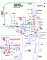
The EPIC is located in Socorro, New Mexico, on the New Mexico Tech campus.
EarthScope Committee Members: find travel tips, expense report forms, and more here.
Information and links regarding public transit information between Albuquerque, Belen and Socorro, can be found on the City of Socorro's website.